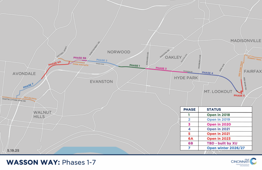
Phases
The Wasson Way is a multipurpose bicycle, running, and pedestrian trail spanning approximately 4.3 miles, running from Old Red Bank Road near Ault Park at the eastern end, westward through Xavier University’s campus, and extending to Blair Court in Avondale. Built primarily on a former railroad corridor and city rights-of-way, it provides a safe, accessible, and scenic route through several vibrant Cincinnati neighborhoods, including Hyde Park, Oakley, Evanston, and Norwood.
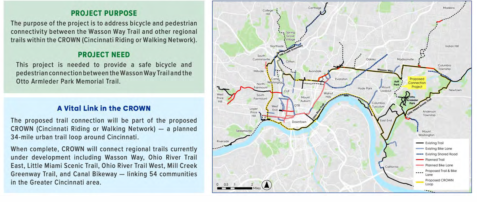
The trail is a cornerstone of the CROWN network, a planned 34-mile urban loop designed to link more than 356,000 residents across Cincinnati to parks, schools, business districts, and regional destinations like the Little Miami Scenic Trail.
Recent expansions, including the 2023 extension into Avondale, have positioned Wasson Way as both a recreational centerpiece and a commuter corridor. Looking ahead, the City of Cincinnati and community partners are advancing Phase 7, which will connect the trail from Blair Court into Uptown at Reading Road and MLK Drive, improving mobility for students, employees, and residents in the medical and university districts.
Once complete, Wasson Way will close a critical east-west gap in Cincinnati’s trail system but also serve as a catalyst for economic development, healthier lifestyles, stronger neighborhood connections, and reduced vehicular traffic. CROWN oversight is provided the Tri-State Trails. You can view the trail here.
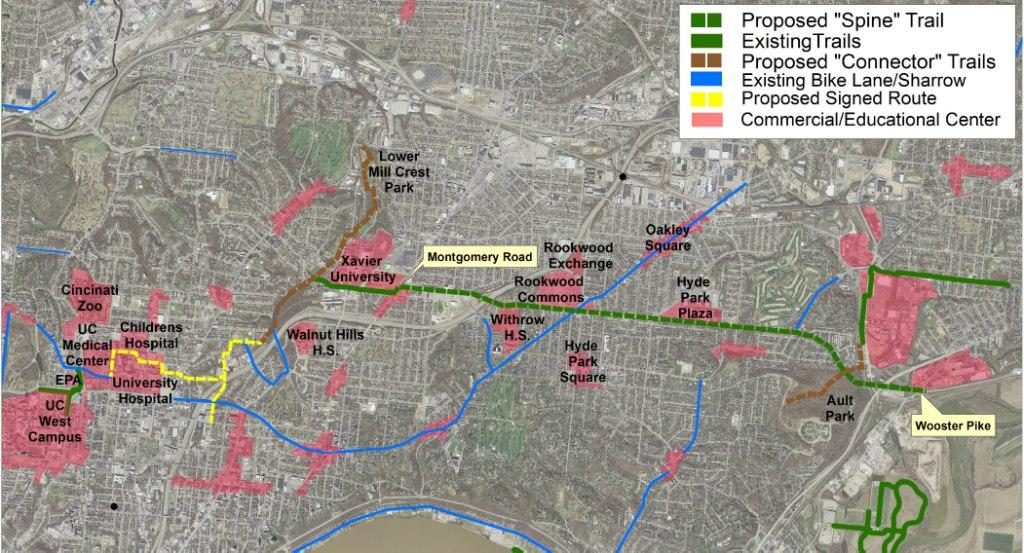
The Wasson Way Trail Network will create a ladder to opportunity for 83,000 residents living in 8 Cincinnati neighborhoods and three municipalities along the trail. The trail network and signed bicycle routes will connect these 83,000 residents to the second largest employment center in the region (the Uptown community), the University of Cincinnati, Xavier University, Withrow High School, Walnut Hills High School, the 70 shops and restaurants in the 25-acre Rookwood Commons shopping center, the new 12-acre Rookwood Exchange retail/office development, the new 15-acre University Station retail/office/housing development and numerous other neighborhood business districts within walking distance of the trail.
The proposed trail network will be transformative to the region in many ways, including: increasing mobility and accessibility, reducing Vehicle Miles Traveled, reducing CO2 emissions, creating travel time savings due to reduced rush-hour traffic congestion, reducing accidents, reducing household transportation costs, and increasing health and wellness.
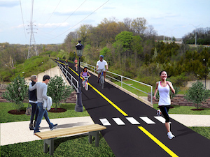
Click here to see landscaping plans for the Wasson Way from the slides of a June 2021 meeting.
Find construction news from the City of Cincinnati by clicking here.
Phase 1
Phase 1 of the trail was constructed in 2018. Phase 1 extends .6 miles from Tamarack Avenue to Madison Road. The cost of construction for Phase 1 was $1.4M. The Ohio Department of Natural Resources awarded this project a Clean Ohio Trails Fund grant in the amount of $500,000, and the Wasson Way donated an additional $50,000.
Phase 2
Phase 2 of the trail was constructed in 2019. Phase 2 extends .7 miles from Tamarack Avenue to Montgomery Rd. The cost of construction for Phase 2 was $3.4M. Phase 2 was awarded $943,000 in federal Transportation Alternatives grant funding and $500,000 from the Clean Ohio Trails Fund.
Phase 3
Phase 3 was completed in 2020. The length of Phase 3 is 1.2 miles, beginning at Madison Road and ending near Marburg Avenue. Phase 3 has construction costs estimated at $2.03M. Work began in summer of 2020 and was completed at the end of 2020.
Phases 4 and 5
Phase 4 from Marburg Ave to the bridge in Ault Park opened in September 2021. Phase 5 from the bridge in Ault Park to Old Red Bank Road opened in December 2021.
Phases 3, 4, 5 and 6 were awarded $6.0M in federal Surface Transportation Program (STP) construction funding, with Phase 3 getting $1.7M of those funds. Phases 4 & 5 will use $2.6M of the federal STP grant funds.
The length of Phases 4 & 5 is 1.25 miles, beginning at Marburg Avenue and ending at Old Red Bank Road. These phases have construction costs estimated at $3.2M. Work began in the summer of 2021 and was completed in December 2021.
Phase 6A
Phase 6A opened on December 13, 2023. The length of Phase 6A is 0.8 miles, beginning at Woodburn Avenue and ending at Blair Court. It was built in an existing Southwest Ohio Regional Transit Authority (SORTA) owned transit corridor between Xavier University and Avondale. It used $1.7M of the federal STP grant funds. This phase has construction costs estimated at $2.0M. Work was planned to begin in summer of 2023 and be completed by spring of 2024.
Source: City of Cincinnati Department of Transportation and Engineering
Wasson Way Future Plans
The Wasson Way is a vital segment of the CROWN trail network—a vibrant active-lifestyle corridor that represents a transformative regional initiative. With several sections already completed and delivering value to adjacent communities, additional phases are in development. Once finished, the network will seamlessly connect premier trails—Wasson Way, Ohio River Trail East, Little Miami Scenic Trail, Ohio River Trail West, Mill Creek Greenway Trail, and the Canal Bikeway—positioning the Sports Club at the heart of Cincinnati’s most dynamic active-lifestyle corridor. [View overall map]
Currently, the trail is accessible from Mariemont through the Xavier campus to Blair Avenue. This westward extension will bring the trail closer to the University of Cincinnati, further strengthening regional connectivity.
Western Expansion
A new intersection at Montgomery Road now allows continuous travel through the Xavier University campus, connecting directly to Woodburn Avenue and Blair Court. Phase 7 of Wasson Way will extend the trail westward from Blair Court to Martin Luther King Jr. Drive in Uptown. The City of Cincinnati is currently planning this one-mile extension, following the City Council Budget and Finance Committee’s approval of the property acquisition resolution.
This phase builds upon the Blair Court segment, which opened in December 2023. The trail will follow the former railroad right-of-way from Blair Avenue to near Ridgeway Avenue, continue along Fredonia Avenue and Whittier Avenue, connect to Reading Road, and proceed to Martin Luther King Jr. Drive.
Engineers are addressing a significant grade change along the route to minimize elevation shifts and ensure full accessibility, including for individuals with mobility impairments. Construction is scheduled to begin in July 2026, with completion expected by the end of 2027.
Eastern Expansion
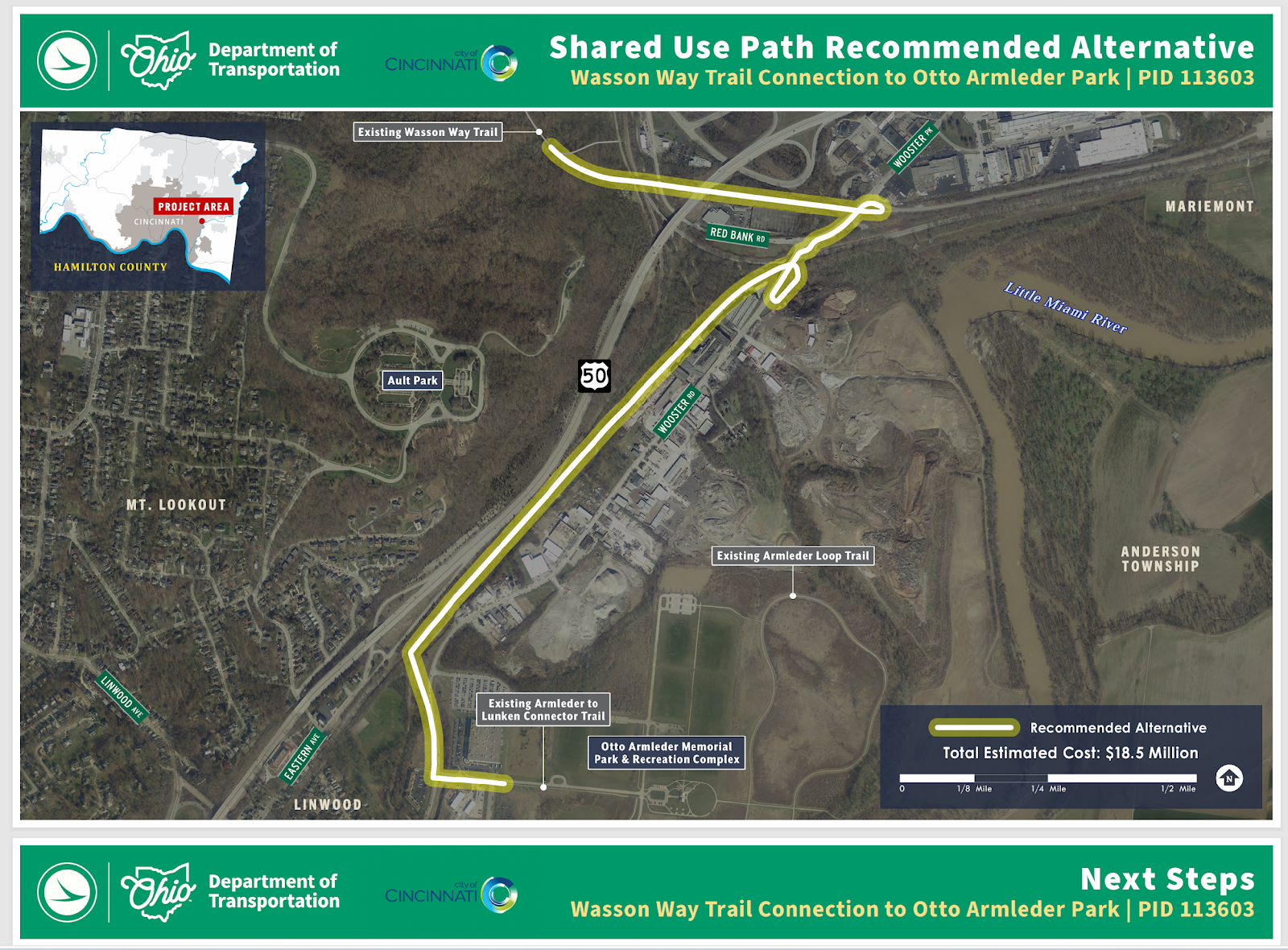
Wasson Way is also collaborating with the Cincinnati City Council and the Ohio Department of Transportation (ODOT) to design and construct an eastward extension from Ault Park to Armleder Park. This new segment will connect to the Lunken Airport Trail and the 78-mile Little Miami Scenic Trail, significantly enhancing regional connectivity and access for thousands of users.
ODOT has completed the feasibility study, and the project is now moving into the design phase. A key feature of the extension is the repurposing of the existing railroad bridge over Red Bank Road, which will serve as a critical connector between trail sections.
The City of Cincinnati is expected to fund and implement this $18.5 million project. The planned shared-use path will support daily trail use, offer alternative commuting options to major employment centers, reduce traffic congestion, and advance the city’s sustainability goals.
This initiative aligns with the 2023 Green Cincinnati Plan and the Connected Communities strategy, and is supported by Tri-State Trails and other nonprofit partners. Wasson Way continues to advocate for stakeholder engagement and additional funding to ensure the successful advancement of the project. [View project information Enter ID 113603] and [View the project schedule here.]