Phases
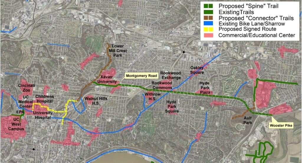
Currently the Wasson Way trail runs for 3.5 miles from Old Red Bank Road at the edge of Ault Park to Montgomery Road at the edge of Xavier’s campus as shown on the map below. An additional .8 miles is open, beginning at Woodburn Avenue and ending at Blair Court.
Take a look at the Ride with GPS link for a step-by-step route that will help you connect with the Murray Path in Fairfax – https://ridewithgps.com/routes/38246324 (thanks to Tri-State Trails for this link).
When completed, the Wasson Way Trail will be a bicycle and pedestrian corridor using trail and signed bicycle routes connecting Uptown and Fairfax. The trail will be located primarily within an unused railroad corridor and existing City right-of-way.

The Wasson Way Trail Network will create a ladder to opportunity for 83,000 residents living in 8 Cincinnati neighborhoods and three municipalities along the trail. The trail network and signed bicycle routes will connect these 83,000 residents to the second largest employment center in the region (the Uptown community), the University of Cincinnati, Xavier University, Withrow High School, Walnut Hills High School, the 70 shops and restaurants in the 25-acre Rookwood Commons shopping center, the new 12-acre Rookwood Exchange retail/office development, the new 15-acre University Station retail/office/housing development and numerous other neighborhood business districts within walking distance of the trail.
The proposed trail network will be transformative to the region in many ways, including: increasing mobility and accessibility, reducing Vehicle Miles Traveled, reducing CO2 emissions, creating travel time savings due to reduced rush-hour traffic congestion, reducing accidents, reducing household transportation costs, and increasing health and wellness.
Click here to see landscaping plans for the Wasson Way from the slides of a June 2021 meeting.
Find construction news from the City of Cincinnati by clicking here.
Phase 1
Phase 1 of the trail was constructed in 2018. Phase 1 extends .6 miles from Tamarack Avenue to Madison Road. The cost of construction for Phase 1 was $1.4M. The Ohio Department of Natural Resources awarded this project a Clean Ohio Trails Fund grant in the amount of $500,000, and the Wasson Way donated an additional $50,000.
Phase 2
Phase 2 of the trail was constructed in 2019. Phase 2 extends .7 miles from Tamarack Avenue to Montgomery Rd. The cost of construction for Phase 2 was $3.4M. Phase 2 was awarded $943,000 in federal Transportation Alternatives grant funding and $500,000 from the Clean Ohio Trails Fund.
Phase 3
Phase 3 was completed in 2020. The length of Phase 3 is 1.2 miles, beginning at Madison Road and ending near Marburg Avenue. Phase 3 has construction costs estimated at $2.03M. Work began in summer of 2020 and was completed at the end of 2020.
Phases 4 and 5
Phase 4 from Marburg Ave to the bridge in Ault Park opened in September 2021. Phase 5 from the bridge in Ault Park to Old Red Bank Road opened in December 2021.
Phases 3, 4, 5 and 6 were awarded $6.0M in federal Surface Transportation Program (STP) construction funding, with Phase 3 getting $1.7M of those funds. Phases 4 & 5 will use $2.6M of the federal STP grant funds.
The length of Phases 4 & 5 is 1.25 miles, beginning at Marburg Avenue and ending at Old Red Bank Road. These phases have construction costs estimated at $3.2M. Work began in the summer of 2021 and was completed in December 2021.

Phase 6A
Phase 6A opened on December 13, 2023. The length of Phase 6A is 0.8 miles, beginning at Woodburn Avenue and ending at Blair Court. It was built in an existing Southwest Ohio Regional Transit Authority (SORTA) owned transit corridor between Xavier University and Avondale. It used $1.7M of the federal STP grant funds. This phase has construction costs estimated at $2.0M. Work was planned to begin in summer of 2023 and be completed by spring of 2024.
Source: City of Cincinnati Department of Transportation and Engineering
Plans for 2024 and beyond
Wasson Way continues to work with the City of Cincinnati, Great Parks of Hamilton County, and the Ohio Department of Transportation to connect Wasson Way with the rest of the CROWN network. Phase 6A of Wasson Way is currently under construction from Woodburn Ave. in Evanston to Blair Court in Avondale and is expected to be open later this year. Early next year, Xavier University will start work on the connection through campus from Montgomery Road to Woodburn. The Villages of Fairfax, Mariemont, and Columbia Township are working to connect the Wasson Way trail head at Old Red Bank Rd. on the east side of Ault Park to the Little Miami Trail in Columbia Township by Bass Island Park. Looking further ahead, we are working with ODOT, the City and the County to explore a connection to Armleder Park. The railroad trestle over Red Bank Road is being evaluated as a key feature in this connection. While many hurdles remain – from land acquisition to funding – once completed this would connect Wasson Way will with trails from Cincinnati to Cleveland. And of course, as part of the 34-mile CROWN loop around Cincinnati, Wasson Way will continue to provide protected access for pedestrians, runners and cyclists to many neighborhoods within the City of Cincinnati.

